Monday 30 January 2012

Mild 'n' 'snowy'?

     The incredibly mild winter weather we experienced in early January has returned to put a close on the likely 2nd or 3rd mildest January on record in the city (wont know until Wednesday if it's 2nd or 3rd). Everyday this week will likely feature highs near zero, and overnight lows likely wont even reach -10 C for a while.
     This milder weather comes with a small price to pay though. Already, some snow has fallen with a clipper system overnight. A general 1 or 2 cm seems to have fallen over the city, not much. It is a little difficult to measure the snow this morning, thanks to strong winds which blew the snow around.
     Although, we are not done with snow just yet. Yet another clipper system following close behind is set to track through southern Manitoba tonight. Some widely scattered flurries have already moved into south western Manitoba this morning. Therefore, some flurries may begin in the WPG area by late afternoon. The bulk of the snow will move through late evening and overnight. Models have been bouncing around with amounts lately, so it is still hard to tell just how much snow we will see. Models are ranging anywhere from 0 to 10 cm. Personally, I'll go in between, and say about 3-4 cm for WPG, although confidence in that is pretty low.
Frz rain and ice pellets possible - GEM for mid/late evening
     The forecast becomes even more complicated when we start adding in the potential for freezing rain and ice pellets. We may enter into a brief period of frz rain and ice pellets in the city this evening. At this point, it appears most of the frz rain will fall south of the Trans-Canada, with areas near the US Border potentially getting a few hours of frz rain. Any frz rain that does fall will significantly reduce the amount of snow we receive. Things will be clearer by evening.
     Models have been handling these systems very poorly this winter, not pinpointing what will actually happen until a few hours before the snow starts. This has made forecasting these systems very difficult.

     In the long-range, at this point it appears this mild weather will continue for at least another week. Next week becomes a little more uncertain, with some models indicating a significant cool down. The CPC still shows temperatures well above normal for the next 2 weeks though, so we will have to wait and see at this point. It is too early to pinpoint exactly when we will cool down. There likely wont be any significant snow in the next week at least neither, other than some snow tonight.
CPC 6-10 day outlook for temperatures

Tuesday 24 January 2012

Our Odd Winter Gets More Odd

     Thanks to a breezy southerly flow we will not drop very low tonight, with a low near -10 or -11 C. Tomorrow will be our next ultra-warm day, with temperatures likely to surpass the freezing mark for the 8th day this month. This will be thanks to 925 mb temperatures between 2 and 5 C and strong winds from the south. We may come close to breaking records tomorrow across southern Manitoba as well. Winnipeg's record is 3.3 C set back in 1942. Personally, I don't think we will break that record tomorrow, although we will be close.
     If winds were to be from a more favourable SW or W direction, and there were to be more sun, tomorrow definitely would have been a widespread record day.
     It will be a little difficult to enjoy the warmth tomorrow however, thanks to very strong south winds which could gust over 50 or 60 km/h. In addition, there will be considerable cloudiness with the chance of some showers, freezing rain and flurries. Not much accumulation is expected though.
     Tomorrow night will be a very mild night, with lows only in the minus single digits ( around -3  to -5 C).

     Beyond that, the good news is that there is no sign of a prolonged cold spell anytime for AT LEAST the next 2 weeks... Temperatures over the next 2 weeks will be generally above normal or near normal, thanks to a return to a more SW or W flow of Pacific air. Cold spells will be very brief, lasting only a day or two, and will not be as overly severe as last week. There may be several occasions in the next while for above zero temperatures!
     This prolonged warm-spell coming up is definitely adding to this strange winter we're having. The AO has just recently plummeted into the negative which would typically mean cold arctic air would spill down more easily. When you mix a strongly-negative AO and La Nina, you'd think we would be seeing brutally cold temperatures, especially at this time of year, though that will not be the case.
IMAGE UPDATES (Jan 26 5:55 PM):
CPC 6-10 day temperature anomaly outlook
CPC 8-14 day temperature anomaly outlook

     The switch to a negative AO though may suggest we may switch to a colder-snowier pattern to end the winter, though there are no guarantees on that at this point.

Saturday 21 January 2012

Sunday Snowfall Forecast

     A low developing in Wyoming will be moving through the Dakotas into Minnesota and Ontario tomorrow into Monday. An inverted trough will extend to the north of the system into Manitoba. At the moment, I am definitely leaning towards a more southern solution, with the bulk of the snow staying to the east and south of WPG. Although, we may still see some snow, thanks to the inverted trough. Speaking of the trough, that is why this forecast becomes so complex. Inverted troughs are notorious for unexpected heavy snowfalls in our area.
     That being said, my prediction for southern Manitoba is as follows:
Snowfall totals from midnight tonight to Monday morning

     I expect about 2-5 cm in Winnipeg, although that is a ball-park estimate. We may get even more than that if more snow develops along the inverted trough than expected, which is what these troughs are notorious for. Perhaps less if the trough doesn't produce much, which is what I am leaning towards.
     What I'm pretty certain is that much of the real system snow will stay to our south and east, in a narrow band grazing south eastern Manitoba. That is why areas just to our south east will likely see higher accumulations of 5-10 cm.
     It's a tough forecast tomorrow though, as it could be a situation of 5 cm in one location, and not even a flake 50 km away. Then again, the inverted trough could produce more snow than expected. We're just going to have wait for tomorrow morning to see just how things really will play out.

Mild with some snow

     Well, we survived winter's first blast of cold! Westerly to south westerly winds Thursday and Friday morning prevented us from reaching -30 C around the city of WPG, thanks to its downslope effects. Although, you did not have to go far to find -30 C. Areas in the eastern RRV weren't as lucky. It got down to -33.4 C in Gimli, and -32.5 C in Sprague Thursday morning. Areas to our west in Saskatchewan and Alberta were not as lucky, with lows well into the -30 s in many areas.
     Here is a map showing the coldest temperatures reached during the arctic spell:

    This really was not a bad arctic blast considering how cold it can get here in some years. We came out lucky. How can we be called Winterpeg if we can't hit -30 C even once!! Not that that is necessarily a bad thing :P
    
    Now to the forecast:
    Today, looks like periods of snow for much of the day, tapering off late afternoon. Perhaps 1-3 cm at most, so it is an insignificant event. Temperatures have warmed after a low of -24 or -25 C overnight, and that trend continues. It will rise closer to our normal high of -13 C today, and will continue to rise until tomorrow.
     Temperatures will rise overnight tonight, and tomorrow we should be in the mid minus single digits. Although, some snow will likely accompany the milder temperatures. Unfortunately, there still lies some uncertainty at the moment into just how much snow we will see tomorrow. There is a variety of solutions given by the models.
     The NAM gives much of southern Manitoba snow tomorrow, with significant accumulations (5-15 cm) over the south east, including WPG.
     The GFS gives only the extreme south east tip of MB some heavy snow. A narrow band, which would just graze the city of WPG.
     The GLB keeps the whole system to our south, with a bit of snow (1-2 cm) associated with an inverted trough attached to the system.

     What do I expect? I'm leaning towards a 5-10 cm event for the south east of MB, and 2-5 cm for Winnipeg, associated with an inverted trough, although I will wait until tonight to give a more in depth opinion, and perhaps a new post to show it.
     After tomorrow though, a brief cool down Monday, back to near normal values, if not even a little bit above, with a warmer second-half of next week.
    

Monday 16 January 2012

Frigid, Chances for Snow

     After record-breaking warmth just a week ago, this week has a whole new face. We're expecting lows in the low minus twenties tonight, between -26 and -28 for the city of Winnipeg. Highs may not even reach -20 C tomorrow!
     Tomorrow night and Wednesday is our next chance for some snow. Models have been in a bit of a disagreement with where the band of snow will end up though. Some are indicating the band will be mainly confined in North Dakota and along the US Border, although others like the NAM have been showing the band sticking over southern Manitoba. Wherever the band ends up, totals could be in the 5-10 cm range in the heaviest hit areas. Personally, I am leaning towards more of a southern track, therefore I am expecting a possible 1-3 cm for the city. Tomorrow things should become more clear, and an update will be provided.
     Behind that system, things will only get colder. Thursday morning could potentially be our first -30 C reading of the season. Daytime highs Thursday will only be in the mid minus twenties :~

     Moderating temperatures are possible by the weekend, with some snow possible Saturday and Sunday, although temperatures will likely only be closer to normal. It is too early to tell at this point just how much snow we may receive, although it does not appear hugely significant at this point. The real warm-up at this point appears to be early next week, with highs possibly getting back into the minus single digits. Stay tuned for the latest updates!

Friday 13 January 2012

Cold Blast Imminent

     The snow has begun over the city already this evening, and will continue after midnight before ending overnight. Not a lot of snow, perhaps 1 or 2 cm. Wind is fairly light, so blowing snow wont be a big problem. Temperatures will slowly rise tonight, and we should be waking up in the morning near -10 or -11 C. It will be a warmer day tomorrow with high near -7 or -8 C. Cloudy skies are expected though, and that is true Sunday as well.
     Sunday will be much milder as a clipper system moves through. Some flurries are expected around the city during the day, perhaps a cm. Although, the bulk of the snow will fall in the Interlake with 5-10 cm possible there. Highs in the city should be near -3 C Sunday. A brisk south wind of 30/50 km/h will make it feel colder than that -3 C though.
     Behind that system Sunday, frigid arctic air will wrap behind the system, and descend Monday. Next week will be frigid with the coldest air we've seen so far this winter. We will wake up Monday in the mid minus teens, although WNW winds of 30/50 km/h will make it feel much colder, similar to last Wednesday. Temperatures wont rise much at all Monday.
     Beyond Monday, the rest of the next week looks frigid with highs barely over -20 C, as well as the possibility for our first -30 C readings since last February.


     Even farther in the future, models have been trending towards a warmer end to January, although that could change...
     Stay tuned for updates.. =)

Tuesday 10 January 2012

Last record warm day for a while..

     Yet another record breaker today. Winnipeg tied its record 5.1 C in 1990, although records were broken in other areas:
 
Location
High Today
Old Record
Records began
Melita
4.3
2.5 (2002)
1993
Gimli
4.7
3.0 (1990)
1945
Fisher Branch
4.9
2.4 (2002)
1978
Winnipeg
5.1 (TIE)
5.1 (1990)
1873
Pinawa
6.5
3.5 (1990)
1964
Gretna
7.5
2.6 (2006)
1956

     It also reached 8.6 C in McCreary and 7.0 C in Emerson.
     We may get a few flurries this evening and overnight, although not much. Much of it is staying to our south and east. We may get some snow tomorrow throughout the day though, and that mixed with winds of 40/70 km/h will cause blowing snow and reduced visibility. I'm expecting about 1-3 cm tomorrow, so nothing major, although it will be a major wake-up call. As a cold front passes later tonight, temperatures will plummit to near -12 to -15 by morning, and stabilize or even drop throughout the day. By evening, temperatures will already be approaching -20 C and we are expecting to drop into the low minus twenties Thursday morning (-22 to -25 C). That along with breezy NW winds will create wind chills we have not seen yet this winter (minus thirties). Thursday will be frigid with highs barely over -20... Friday morning will be another frigid start with lows again into the mid minus twenties. .. Ouch!
     It will be a brief surge of cold air though, as temperatures warm back up by the weekend. Expect highs back in the minus single digits, Sunday being the warmest. It appears the cold will return next week, although certainty in that is unknown at the moment. With a positive and rising AO still, cold blast should be brief, but that could change....
Stay tuned..

Monday 9 January 2012

Another Record-Breaker..

     The balmy-January weather we've been spoiled with continued today throughout southern Manitoba. We have now seen 31 consecutive days above normal here in the 'Peg. Not as many records were broken compared to last Thursday, although some were:

Location
Today’s High
Old Record
Records Began
Thompson
-3.4
-3.8 (1983)
1967
Brandon
4.5
4.4 (1986)
1890
Sprague
5.9
5.0 (1958)
1916
Gretna
8.0
7.2 (1958)
1956
Melita
8.6
3.9 (2006)
1993

     We reached 4.3 C at the airport in Winnipeg today, just shy of the record of 5.6 C in 1958. Many parts of the city reached 5 C today, including 5.5 C here at my station in the south end. The snow pack around the city quickly melted today, with patches of grass visible again here and there in the city. There is little to no snow on the ground still in the western RRV, and areas along the International Border. As a result, those areas managed to reach between 5 and 8 C today. Here are some images and webcam photos of the lack of snow cover over much of the Prairies, VERY unusual for this time of year...
 Emerson
St. Vital


Visible Satellite 1 PM Jan 9


     Temperatures have been dropping steadily this evening thanks to clear skies, although they should begin to stabilize and even rebound by mid evening as cloud cover starts moving in. It is now cloudy in Dauphin, which has allowed temperatures to rebound by 3 C in the past hour.
     Tomorrow of course will be our last warm day for a while. It's a little tough determining just how warm it will get. Cloud cover may limit our temperature climb somewhat, although 925 mb temperatures near 1 to 4 C and a breezy westerly flow will allow for above zero temperatures for the 7th day this month! I believe Winnipeg has a good shot at 2 or 3 C tomorrow, while the western RRV, and near the International Border in the southern RRV may reach between 4 and 6 C. Have to wait and see if we can get a good amount of sunshine, or else those temperatures could be a degree or two cooler if we stay cloudy.
     UPDATE (Jan 10/7:45 AM): With 925 mb temperatures now expected to be between 6 and 10 C today, I'm expecting a high of 5 or 6 C in Winnipeg today, and 7 to 9 C in western RRV. It looks like a mix of sun and cloud today, rather than all-out cloudy.
     We could still see some flurries tomorrow night and Wednesday with the passage of a cold front. I don't see any major accumulations, with perhaps one or two cm at most. The big story will be the cold, with falling temperatures Wednesday. Temperatures by late afternoon could be as low as -15 to -18, so bundle up! Winds will be strong from the northwest 40 to 60, so windchills will be a lot lower than we've been accustomed to. Thursday will be downright frigid. At this point, models are pointing at morning lows in the mid minus twenties, with highs between -17 and -20. BRRR! But quite frankly, that's only just closer to normal!....
Stay tuned for the latest updates...

Sunday 8 January 2012

January Warm Spell Continues.... For Now

     So far, you wouldn't know it was January out there in Manitoba, and much of southern Canada. And it looks likely we will continue to see very above normal temperatures here in southern Manitoba until at least Tuesday. In fact, tomorrow we could come close to record-breaking warmth in some areas. It looks like we will have a favourable westerly flow tomorrow, taking advantage of downsloping for the RRV. It won't be a very strong wind, although it may just be enough. NAM is showing 925 mb temperatures between 3 and 5 C around Winnipeg, and 6 to 8 C in western RRV and southwest Manitoba. Not as high as they were back on Thursday.
     As a result, I don't expect to see temperatures as high as last Thursday, although we will still come close to records. I think Winnipeg has a pretty good chance at a high of 4 or 5 C, while western RRV could get temperatures as high as 7 or 8 C especially in non-snow covered areas. Winnipeg's record tomorrow is 5.6 C in 1958, I don't think we will break that record, but we may come close.
     Tomorrow night will definitely be very mild. Lows look to be between -2 and 0 C. And that will start off our last ultra-warm day. Highs should be generally around 1 C, while perhaps a couple degrees milder in western RRV.

     It's Tuesday night that things start to turn around. After some light snow or showers Tuesday evening switching over to light snow overnight, temperatures will begin to take a dive. I don't see any major accumulation from that snow, perhaps 1-3 cm at worst. Temperatures will actually fall during the day on Wednesday with strong northwest winds 40 gusting to 60 km/h. Just how far the temperatures will drop is up to debate at this point. Definitely into the minus teens. Will be a rude wake-up call for sure. It does appear as though temperatures will stay closer to normal from then on. I don't see any deep frigid arctic air though at this point ( -30s/-40s )  so if you don't like brutal cold, that's good news. Although, there lies great uncertainty at this point. The AO is starting to slip towards negative, but that could change...
Average high around this time of year is near -13, while normal low is near -23.
Stay tuned....

Top 10 Weather Events of 2011 - #1

#1 Our Seemingly Endless Summer    

A tale of sunshine

     After a wet and cool spring, the taps turned off in late June as the weather pattern began to change. A ridge in the jet stream centered over central-eastern North America kept things sunny, hot, and dry all summer over southern Manitoba. These ongoing conditions spelt severe drought. As far as outdoor enthusiasts were concerned, this summer was as good as it gets in Manitoba. As for farmers, it was a completely different story.

     The sudden turn from record flooding, to record drought was hard on many farmers. The soil had already dried out by late July. Crops began shutting down and turning yellow, and roots were not deep enough. What little they were able to seed in spring was barely surviving the summer. On the bright side, one seasoned-grower stated, ‘‘I could be receiving flood and drought insurance payments at the same time’’.
July rain % of normal
     July was the driest on record in Winnipeg with a measly 10.0 mm of rain, beating the previous driest July of 10.5 mm in 2006. Normal rainfall for July is about 70 mm, therefore we only received 14% of our normal rainfall. Other parts of the city received more or less what the airport received. About 20-25 mm fell in North Kildonan and East St. Paul, while just 8-10 mm fell along the south Perimeter.  The drought was more of a southern and south eastern Manitoba problem in July. Parts of south western Manitoba and the Interlake received over 50 mm of rain for the month.
     August was also very, very dry. Although, heavy thunderstorms on the 18th dumped 15-25 mm over the city and ensured that August would not be one of the driest on record. That rain event did very little to ease the drought though. The rain came down very fast and did not have enough time to soak into the ground. Hot temperatures in the mid to high thirties a few days later ensured that any moisture had quickly disappeared.
Lawns were parched this summer
     In Winnipeg, this summer (June, July, August) ended up being the 5th driest summer on record since 1873. Only 93.0 mm of rain fell, 40% of normal. From June 23 to August 18 (56 days), no daily rainfalls over 3 mm were recorded. In addition, it rained on only 4 Saturdays and Sundays out of 27, truly as good as it gets in Manitoba. Storms were consistently bypassing the south east, moving from Saskatchewan into the Interlake and North Dakota all summer. Even though we were in a drought, there was no shortage of water. Rivers and lakes were still flooding over nearby land after a record-breaking flood this spring. The driest summer ever was in 1929, with just 76.7 mm.
     After a generally seasonal June, the heat turned up a notch by the end of the month. In general, the heat stayed for the rest of the summer. The 3 month mean (JJA) of 19.5 C was 1 C above average, and tied for 17th hottest summer on record. 19 days saw temperatures over 30 C while 35 days saw temperatures over 28 C. The hottest summer on record was 1988 with an average mean temperature of 21.0 C.
     In addition, there were virtually no mosquitoes this summer. A cool spring followed by a very dry summer meant mosquitoes could not breed. In Winnipeg, this summer featured the lowest mosquito-count since 1980. We gladly passed on the title of mosquito-capital to Edmonton. Edmonton was swarmed with the worst mosquitoes in a decade, thanks to record rainfall in June and July.
     Rather than mosquitoes, wasps were the bigger problem this summer. They were a little more aggressive this summer since there was less food for them. The dryness was reducing the amount of flowers. They became aggressive searching for other sources of food. Pest Control businesses reported twice the amount of calls as the previous year.  

     Fire bans became the name of the game by early August. The provincial government banned all fires and burning in Eastern Manitoba and in many provincial parks, including the Whiteshell and Sandilands. Access to the back-country was also banned in some areas, to avoid fires sparked by ATVs, or other motorised vehicles. The ban was put into place after a small forest fire forced the evacuation of a campground in the Whiteshell. The fire rating was pushed to extreme, therefore we could not take chances. Any fire that develops would spread quickly, especially with wind, and would be hard to contain. Lightning was already sparking fires almost daily in the east, so the ban was put in hope that at least the amount of man-made fires could be reduced. The penalty for violating the ban was up to $1,000.
     Many communities, including the city of Winnipeg, issued their own bans to compliment the provincial ban which only affected provincial land.

     In the end, it was consistently hot, dry and mosquito-free all summer. Our seemingly endless summer will definitely be known as one of the most pleasant summers in recent memory.
Grand Beach / Manitobaphotos.com
 
Also with reference from :
Philips, D., Canada’s Top Ten Weather Stories for 2011. (2011): page 4, 7. Access 01/08/12 from < http://www.ec.gc.ca/meteo-weather/default.asp?lang=En&n=8E2C07A1-1 >

Saturday 7 January 2012

Top 10 Weather Events of 2011 - #2

#2 Summery October    

     The first third of October was very warm, very dry, and at times very windy. An upper ridge of high pressure centered over central North America was the culprit. Every day from Oct 1 to 12 saw above normal temperatures, including 8 which saw temperatures over 20 C. Although, it was particularly hot from Oct 4 to 7. Manitobans welcomed the return of mid-summer temperatures, although those warm temperatures came with some real consequences. The following is a summary of the extreme and odd weather we experienced Oct 4 to 7.

     Temperatures from Oct 4 to 7 were 10 to 20 C above normal. Forget about the normal high of 14 C, and normal low of 2 C. Highs were in the high twenties to low thirties, and lows in the mid to high teens.
     October 5 featured the peak of the heat. A very strong south wind pumped in 925 mb temperatures of 25 C (see 925 mb plot). That translated into daytime highs in the low thirties throughout southern Manitoba. 925 mb temperatures of 25 C are very extreme for October. In comparison, that would translate into temperatures in the high thirties in the summer with plentiful sunshine. By noon, it was already 26 C in WPG, and by afternoon, the temperature peaked at 31.1 C. It was the hottest October day in the city’s history, beating the previous hottest October day of 30.5 C on Oct 1, 1992. Much of southern Manitoba reached the 30 degree mark, and broke records. Many took advantage of this late summer treat to go swimming at beaches such as the one at Birds Hill Park. It would have been quite surreal to be sitting at the beach in a bathing suit, or splashing in the water in October.
     Winnipeg has hit 30 C in October only 3 times since 1872, proving how rare this October day was.  Although, parts of the western RRV have hit 30 C many times in October, and have hit 30 C as late as October 16. Here are some selected highs attained October 5. Official records are in bold:
Location
Oct 5 High
Old Record
Records Began
28.3
24.4 (1943)
1906
30.9
29.4 (1943)
1890
31.1
28.3 (1943)
1872
31.8


32.8
29.4 (1943)
1886

     Comparatively, Mexico City reached a high of 26.2 C that same day.
     At night, temperatures stayed very warm thanks to a strong southerly wind. In WPG, it was still 24.1 C at 11 pm. In addition to the record high on Oct 5, a record high minimum of 16.1 C was also broken. A low of 16.7 C on Oct 6 also broke a high minimum record, and was the 2nd warmest high minimum in October history. The warmest minimum was 17.2 C in 1897, which we almost broke on Oct 7. The morning low was a jaw-dropping 19.1 C, but a cold front in the afternoon cooled temperatures enough by evening that we did not break it.

     That same cold front triggered thunderstorms throughout the south in the afternoon. Lots of lightning, heavy downpours and pea to marble sized hail were reported in the Interlake. As if it didn’t feel like summer enough already!
Photo is from a Theweathernetwork viewer
     Behind the front, winds picked up drastically. Winds gusting over 90 km/h caused severe damage. To give an idea of the strength of the winds, a camper trailer being towed by a truck on Hwy 59 got picked up by the winds and landed on the truck towing it, which then veered into oncoming traffic. Luckily, there were no injuries. In the city, trees were uprooted, some landing on power lines, poles and transformers. Numerous traffic lights flickered, with power outages throughout the area. Manitoba Hydro had to call-in extra emergency-repair crews to fix all the outages that were occurring. Thousands were without power at one point. Some trees landed on homes, garages, and fences, keeping tree services very busy the next day.

     And finally, the warmth, strong winds, very low humidity and very dry soil conditions all combined to create ideal conditions for fires. Environment Canada does not issue warnings for fire weather, although, the fire weather watches and red flag warnings in North Dakota and Minnesota could have just as easily been extended into southern Manitoba. The fire rating was pushed to extreme, the second time this year. Fire and burn bans were issued in some areas to avoid man-made fires.
     Several fires did in fact pop up throughout southern Manitoba during that week. Many were small fires, although there were also a number of large fires as well, such as in:
·         RM of Stuartburn – RM declared a state of emergency. 60 people evacuated in the town of Stuartburn, 90 km south of WPG. Several firefighters and 4 water bombers fought at least 4 serious fires, saving all property. Hwy 59 & 201 were closed as a result of fire and smoke. 100    were also evacuated near Caliento, Lonesand and Zhoda as fires crept closer to those communities.
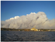
Riding Mountain fire
·         Riding Mountain National Park – Firefighters from Saskatchewan and BC were flown in to help battle the flames. The fire began where a controlled burn had previously been extinguished in late September. All roads, highways and trails east of Hwy 10 were closed. 2,000 hectares of land burnt, in an area 12 km long from south to north.
·         Bissett – Firefighters from Ontario and BC were flown in to help battle an 18,000 hectare fire about 10 km north of the town of Bissett. 8 helicopters, 4 water bombers, and around 100 ground crew fought the flames. The fire covered an area 40 km long and 6 km wide. Hwy 304 was closed due to heavy smoke and flames. This large fire was ignited by lightning.
·         Sandilands/Woodridge – 400 were evacuated as flames approached the communities. 20,000 hectares of land was burned. Smoke from the fire also forced an additional 350 people out of their homes in Marchand before wind changed direction.
·         Peguis First Nation – 1 500 hectares of land was burned.
     Several other small fires sprung up as well, such as near Lac du Bonnet, Bird Lake and La Broquerie. Cooler temperatures, higher humidity and lighter winds improved the situation immensely by Oct 9 and beyond. This many fires in October are definitely fairly unusual. All in all, it was an extremely unusual week of summer heat, vicious winds, grass fires and thunderstorms. This kind of weather in October may never be repeated in a lifetime, and will be remembered for years to come.
References:
CBC Manitoba, Fires rage across Manitoba, force evacuations. (Oct 7, 2011). Access 12/22/11 from < http://www.cbc.ca/news/canada/manitoba/story/2011/10/07/mb-fire-smoke-manitoba.html >
CBC Manitoba, Fire creeps toward Manitoba villages. (Oct 8, 2011). Access 12/22/11 from < http://www.cbc.ca/news/canada/manitoba/story/2011/10/08/manitoba-fires.html>
CTV Winnipeg, Controlled burn turns into wildfire in Riding Mountain National Park. (Oct 7, 2011). Access 12/22/11 from < http://winnipeg.ctv.ca/servlet/an/local/CTVNews/20111007/wpg_swfire_111007/20111007/?hub=WinnipegHome >
CTV Winnipeg, Weather cooperating with fire fight in southeastern Manitoba. (Oct 9, 2011). Access 12/22/11 from< http://winnipeg.ctv.ca/servlet/an/local/CTVNews/20111008/wpg_fire_111008/20111008/?hub=WinnipegHome>
Winnipeg Free Press, Firefighters battle blazes across the province. (Oct 7, 2011). Access 12/22/11 from < http://www.winnipegfreepress.com/local/breakingnews/Strong-winds-worsen-fire-near-Stuartburn-131340563.html >
Winnipeg Free Press, Wind storm keeps hydro, city and firefighters busy. (Oct 7, 2011). Access 12/22/11 from < http://www.winnipegfreepress.com/breakingnews/Wind-storm-keeps-hydro-crews-scrambling-131366558.html >